
Sak-Bahlán: the Lacandon Maya city that resisted colonial rule
Gobierno de México, INAH
Created: July 25, 2025
Translated from Spanish with DeepL
For more than a century, a Mayan group known as the Lacandon-Ch'olti'es maintained their independence deep in the Chiapas jungle. Sak-Bahlán (“White Jaguar”) was the name of the city that was their last stronghold, where they resisted the advance of the colonial regime after their capital, Lacam-Tún (“Great Rock”), was taken by the Spanish in 1586, until, in 1695, Spanish friars and soldiers found its location. Shortly thereafter, the city was subjugated and renamed Nuestra Señora de los Dolores.
Over time, the jungle swallowed up its temples and roads. But three centuries later, archaeologists and experts in historical geography believe they have rediscovered this ancient rebel city. The site, registered in the research project as “Sun and Paradise. Probably Sak-Bahlán,” is located in the heart of the Montes Azules Biosphere Reserve and has been explored thanks to digital models that helped trace ancient pre-Hispanic routes between rivers, jungles, and plains.
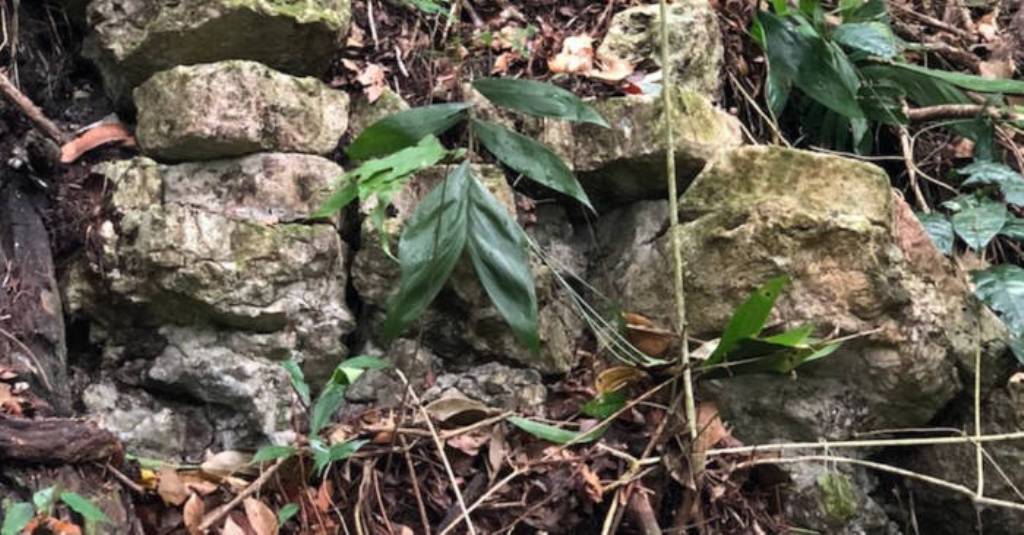
Archaeological research is beginning to reveal the remains of this city, whose squares and structures are once again coming to light as historical evidence of a people who resisted foreign rule to the very end.
Read the full story in our newsletter: Sak-Bahlán, what could be the last city of the Lacandon rebels of Chiapas, has been located:
Created: July 24, 2025
- An archaeological project, co-directed by Dr. Brent Woodfill and Dr. Yuko Shiratori, believes it has found the lost “land of the white jaguar.”
- Using a predictive model based on GIS, INAH researcher Josuhé Lozada developed a map to locate it.
“This book is about ethnocide,” Jan de Vos begins La paz de Dios y del rey (1988), a narrative about the colonial system that annihilated the Lacandon-Ch'olti'es, the last Mayan rebels of Chiapas, whose final stronghold, Sak-Bahlán, was spotted in 1695 by Fray Pedro de la Concepción and, shortly thereafter, subjugated and renamed Nuestra Señora de los Dolores.
The site was abandoned in 1721 and swallowed up by the jungle, until now, three centuries later, when the Sak-Bahlán Archaeological Project, co-directed by Dr. Brent Woodfill and Dr. Yuko Shiratori from Winthrop University in the United States and Rissho University in Japan, believes it has found the “land of the white jaguar.”
This search through the Montes Azules Biosphere Reserve would have been fruitless without the guidance of researcher Josuhé Lozada Toledo from the National Institute of Anthropology and History (INAH), who created a predictive model using Geographic Information Systems (GIS) to locate the settlement, which had eluded other expeditions, including one in 1999 organized by Conservation International, in which historian Jan de Vos himself participated.
The site was registered by the research initiative, which is endorsed by the INAH Archaeology Council, as “Sol y paraíso. Probablemente Sak-Bahlán” (Sun and Paradise. Probably Sak-Bahlán) in the Public Registry of Monuments and Archaeological and Historical Sites.
Josuhé Lozada, a specialist at the INAH Chiapas Center, explains that the Lacandon-Ch'olti'es maintained their independence in this place for 110 years after their capital, Lacam-Tún (“Gran Peñón”), was taken by the Spanish in 1586.
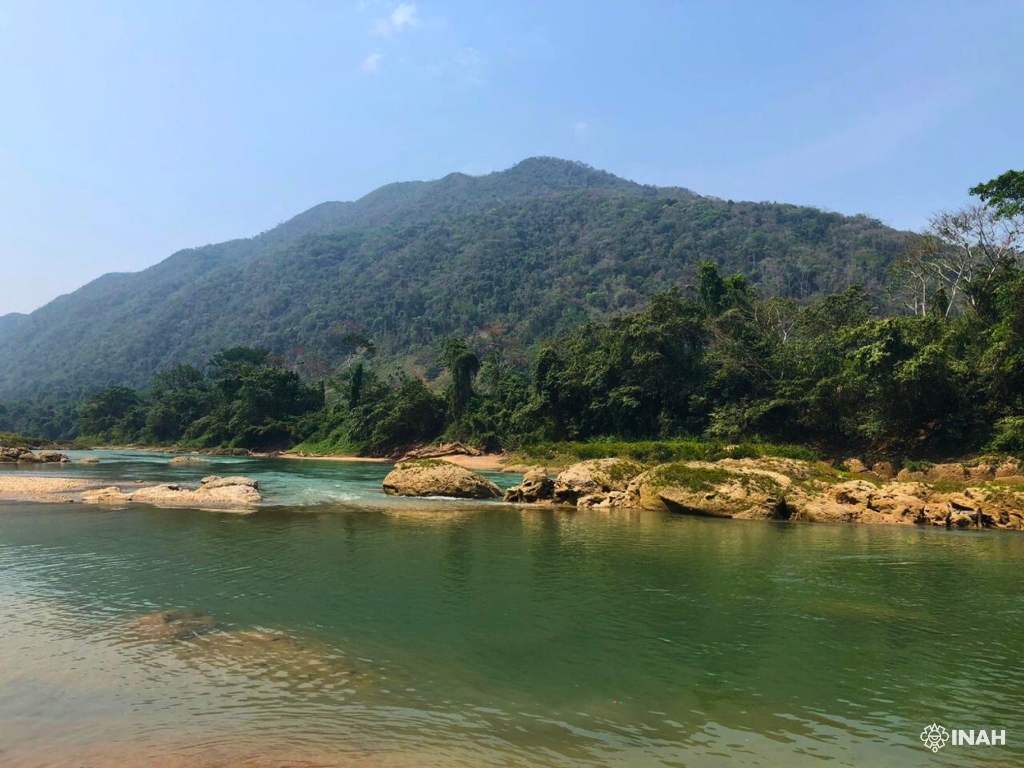
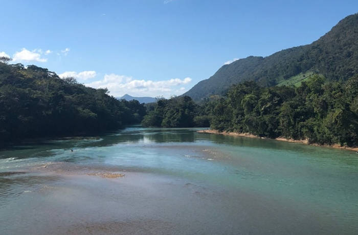
It is known from historical documentation on the aforementioned 1695 entry into Sak-Bahlán, including a letter from Fray Diego de Rivas, that the Lacandon enclave was located on a plain surrounded by the curve of the Lacantún River.
Using GIS, Lozada Toledo reconstructed the pre-Hispanic and historical communication routes of the Mayan groups. Using ArcGIS Pro software, he introduced layers of information to perform calculations and predictive analyses.
I took data from the chronicle of Friar De Rivas, from 1698; for example, he recounts that, that year, he and a troop of soldiers left Nuestra Señora de los Dolores (formerly Sak-Bahlán) and walked four days to the Lacantún River. They sailed for two days and arrived at El Encuentro de Cristo, where the tributary joins the Pasión River, and left their canoes to then walk to Lake Petén Itzá in Guatemala.
“From those places mentioned, which I had georeferenced, I converted the four days referred to, from some point on the Lacantún River to Sak-Bahlán,” he explains.
He explains that he considered various variables: the territory, i.e., the altimetry and vegetation layers; the water bodies layer; and the weight of the cargo per person. “By combining all these variables, I was able to make the proposal on the map and obtain an approximate range of where the Sak-Bahlán site could be located.”
The predictive model created by the archaeologist, which will be published in the next issue of Chicomoztoc magazine, was the compass for the research project funded by the Discovery Channel. The journey is the focus of the documentary Discovering the Hidden Mayan City: Sac Balam.
For Lozada, this experience, in which Mexican archaeologists Rubén Núñez Ocampo and Socorro del Pilar Jiménez Álvarez also participated, is similar to that of 19th-century explorers, but with satellite internet: “It's the most difficult field trip I've ever been on, but in the end, we found the archaeological evidence, right where I had marked it.”
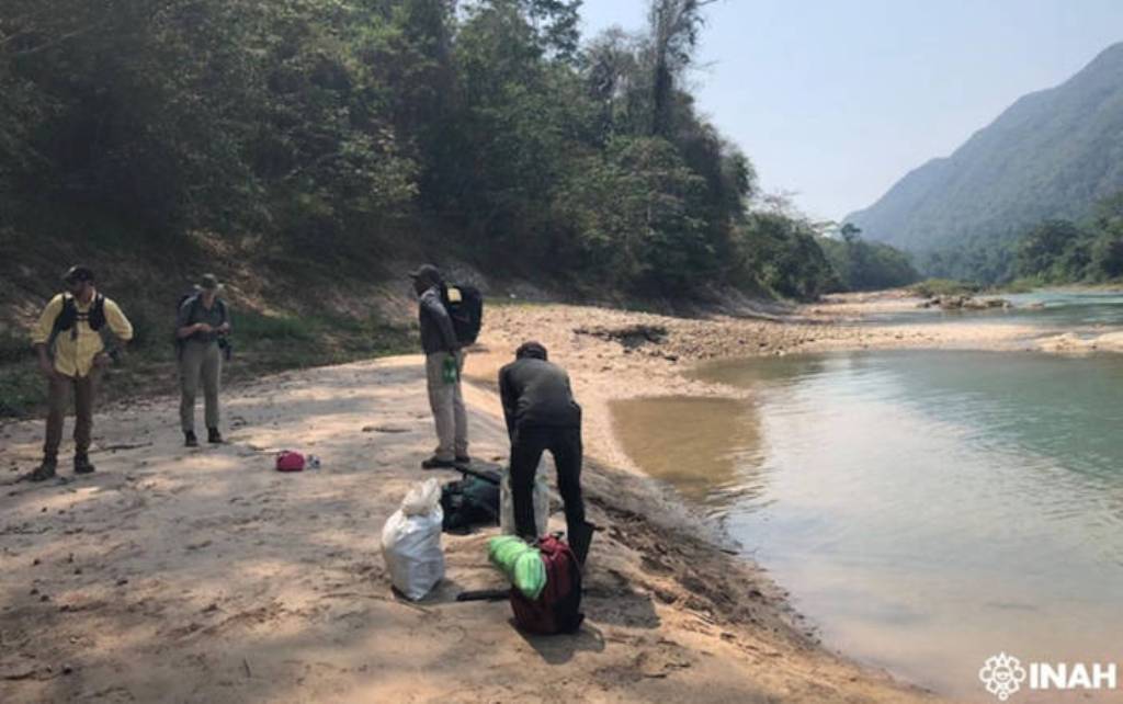
Its location, close to the Jataté and Ixcán rivers, marks the beginning of a story that will intertwine viceregal chronicles and material evidence. So far, the archaeological project has carried out two field seasons to map the site and drill test pits to determine its temporal occupation.
As Jan de Vos recounts, in 1769, the mayor of Suchitepéquez, Guatemala, in search of the extinct town of Dolores, “found in an abandoned neighborhood of the town of Santa Catarina Retalhuleu, the last three survivors of the tribe that had once been the terror of the Christian Indians and the nightmare of the Spanish government.” Three centuries later, Sak-Bahlán is back on the map.
oooooooooooooooooooooooooooooooooooooooooooooooooooooooooooo
Lost Maya Rebel City in ‘Land of the White Jaguar’ Located
Ancient Origins
by Gary Manners, Updated 26 July, 2025
After three centuries buried beneath Mexico's dense Lacandon jungle, archaeologists believe they have finally located Sak-Bahlán - the legendary "land of the white jaguar" and last stronghold of the rebellious Lacandon-Ch'olti' Maya who resisted Spanish conquest for over a century. The discovery of this long-lost city represents the culmination of decades of searching by historians and archaeologists, guided by advanced Geographic Information Systems (GIS) technology that pinpointed the exact location where the final Maya rebels made their stand against colonial forces.
The site, formally registered as "Sol y paraíso. Probablemente Sak-Bahlán" in Mexico's Public Registry of Archaeological and Historic Monuments and Zones, was located through groundbreaking predictive modeling developed by INAH researcher Josuhé Lozada Toledo. His breakthrough came from analyzing 17th-century Spanish chronicles, particularly those of Friar Diego de Rivas from 1698, which described the treacherous journey to this remote Maya refuge, says an INAH report.
The project, co-directed by experts from Winthrop University (USA) and Rissho University (Japan), includes the participation of INAH. (Josuhé Lozada/CINAH Chiapas)
The Last Bastion of Maya Resistance
According to the report, Sak-Bahlán served as the final refuge for the Lacandon-Ch'olti' Maya after Spanish forces captured their original capital, Lacam-Tún ("Great Rock"), in 1586. For 110 years, this remote settlement maintained its independence in the heart of what is now the Montes Azules Biosphere Reserve, becoming a symbol of indigenous resistance against European colonization. The site was first documented by Spanish missionaries in 1695, when Friar Pedro de la Concepción glimpsed the fortified settlement during a missionary expedition.
According to historical records, Sak-Bahlán was strategically positioned on a plain surrounded by the meandering curves of the Lacantún River, making it nearly impregnable to Spanish attack. The Maya inhabitants utilized the natural terrain to their advantage, creating what historian Jan de Vos described in his seminal work "La Paz de Dios y del Rey" (1988) as the final chapter in an indigenous tragedy - or as he bluntly stated, "This book deals with ethnocide."
The Spanish eventually conquered Sak-Bahlán and renamed it "Nuestra Señora de los Dolores" (Our Lady of Sorrows), but the settlement was abandoned by 1721 as colonial pressures and disease decimated the population. By 1769, Spanish records indicate only three survivors remained from what had once been a thriving community.
The archaeological project has conducted two field seasons to map the site and construct test pits to determine its temporal occupation. (Josuhé Lozada/CINAH Chiapas)
GIS Technology Solves Historical Mystery
The breakthrough in locating Sak-Bahlán came through innovative archaeological methodology combining historical documentation with cutting-edge technology. Lozada Toledo used ArcGIS Pro software to create predictive models based on colonial-era travel accounts, topographic data, vegetation patterns, and water sources. His analysis of Friar Diego de Rivas's detailed 1698 chronicle proved particularly crucial.
"I took data from the friar De Rivas's chronicle of 1698; for example, he narrates that year, he and a troop of soldiers departed from Nuestra Señora de los Dolores (formerly Sak-Bahlán) and walked four days to the Lacantún River," explained Lozada Toledo. By georeferencing known locations and calculating travel times based on terrain difficulty and cargo loads, he identified the most probable location for the lost settlement.
The international research team, co-directed by Dr. Brent Woodfill from Winthrop University and Dr. Yuko Shiratori from Rissho University in Japan, received funding from Discovery Channel to document their expedition. The search location, near the confluence of the Jataté and Ixcán rivers, proved to match exactly with Lozada's GIS predictions.
Tzendales River. (Josuhé Lozada/CINAH Chiapas)
Rediscovering Maya Resistance History
The discovery of Sak-Bahlán provides crucial archaeological evidence for understanding the final phases of Maya resistance against Spanish conquest. Unlike other Maya settlements that fell quickly to European diseases and military might, the Lacandon-Ch'olti' people maintained their independence through strategic isolation and fierce resistance.
Previous expeditions had attempted to locate Sak-Bahlán, including a 1999 expedition by Conservation International that included historian Jan de Vos himself, but the dense jungle and challenging terrain had kept the site hidden. The current project represents what Lozada describes as "the most demanding fieldwork of my life," requiring satellite internet connections and extreme physical endurance to reach the remote location.
Archaeological teams have completed two field seasons mapping the site and conducting test excavations to determine its temporal occupation. While full excavation results remain pending, initial findings confirm human occupation consistent with the historical period of Lacandon-Ch'olti' resistance (1586-1695 AD).
Legacy of Maya Cultural Survival
The rediscovery of Sak-Bahlán adds a crucial chapter to the complex history of Maya civilization in Chiapas and provides physical evidence of indigenous resistance strategies. The site's remote location in the Montes Azules Biosphere Reserve, one of Mexico's most biodiverse regions, illustrates how the Lacandon-Ch'olti' people used their intimate knowledge of jungle terrain to maintain autonomy.
The broader significance extends beyond archaeology to contemporary indigenous rights issues. The Lacandon jungle remains home to modern Maya descendants who continue facing challenges from development pressures, deforestation, and cultural preservation needs. The discovery of Sak-Bahlán offers validation of indigenous historical narratives that Spanish colonial documents often dismissed or minimized.
The research project, which will be featured in the Discovery Channel documentary "Discovering the Hidden Maya City: Sac Balam," demonstrates how modern technology can unlock historical mysteries. Lozada Toledo's methodology will be published in the upcoming issue of Chicomoztoc magazine, potentially revolutionizing how archaeologists search for lost Maya cities throughout Mesoamerica.
oooooooooooooooooooooooooooooooooooooooooooooooooooooooooooo
Archaeologists discover the “Land of the White Jaguar,” the Mayan city that was a refuge for the last Lacandon rebels in Chiapas.
Sak Bahlán may have finally been found after more than three centuries of neglect.
Xataka, by Josué González Aranda, July 26, 2025
Translated from Spanish with DeepL
The National Institute of Anthropology and History (INAH) has revealed that Sak Bahlán, the last settlement of the Lacandon-Ch'olti'es, has been located. This is the last variant of rebel Mayans that survived the Conquest in Chiapas. The last record of the site dates back to 1695, when it was subjugated by Fray Pedro de la Concepción.
The discovery was made possible thanks to the use of a modern predictive model of Geographic Information Systems (GIS) that researcher Joshué Lozada applied to the archaeological project. Pre-Hispanic communication routes of the Mayan groups were successfully reconstructed. The project was funded by the Discovery Channel.
The Lacandon Jungle in Chiapas is named after the people who inhabit it: the Lacandon. Before the arrival of the Spanish, the Mayan culture, from which the Lacandon people originated, numbered up to 13 million inhabitants. Today, the Lacandon group numbers no more than 1,500 people. Even so, they have left a legacy of resistance and perseverance, as they are considered the last Mayan rebels to inhabit Chiapas.
In 1695, Fray Pedro de la Concepción led the conquest of the last of their cities: Sak Bahlán (Land of the White Jaguar). The site was renamed Nuestra Señora de los Dolores, but it only remained standing for 26 years, until it was abandoned in 1721 and swallowed up by the jungle. However, its records prevented it from falling into oblivion, which allowed the launch of the Sak-Bahlán Archaeological Project, led by Dr. Brent Woodfill of Winthrop University, United States, and Dr. Yuko Shiratori of Rissho University, Japan.
A fusion of modern technology and historical archives
Josuhé Lozada, a specialist at the Chiapas INAH Center who developed the map, explained that the Lacandon-Ch'olti'es survived as an independent people for 110 years after their capital Gran Peñón (Lacam-Tún) was invaded in 1586. Multiple records by the conquistadors, such as those of Fray Pedro de la Concepción and Fray Diego de Rivas (in 1695), provide details about the location of Sak Bahlán, such as its location on a plain surrounded by the Lacantún River.
"I took data from the chronicle of Friar De Rivas, from 1698; for example, he recounts that, that year, he and a troop of soldiers left Nuestra Señora de los Dolores (formerly Sak-Bahlán) and walked four days to the Lacantún River. They sailed for two days and arrived at El Encuentro de Cristo, where the tributary joins the Pasión River, and left their canoes to then walk to Lake Petén Itzá, in Guatemala." Josuhé Lozada, specialist at the Chiapas INAH Center
By combining chronicles from the colonial period, river routes, and topographical maps, Lozada developed a predictive GIS model that allowed him to narrow down the most likely location of Sak Bahlán, which coincides with a site near the Jataté and Ixcán rivers where archaeological remains have recently been discovered.
The finding is currently listed in the Public Registry of Monuments and Archaeological and Historical Sites under the entry “Sun and Paradise. Probably Sak-Bahlán.” In addition, the results will be featured in the documentary Discovering the Hidden Mayan City: Sac Balam, produced by the Discovery Channel.
To date, there are still many Mayan cities that remain lost, and whose existence we only know about thanks to the records of their conquerors. Several of them have been found by mere accident, while others are believed to have been completely looted.
oooooooooooooooooooooooooooooooooooooooooooooooooooooooooooo
The Lost City of White Jaguar discovered in the Lacandon Jungle, a new archaeological site
The archaeological site, located in the Montes Azules Biosphere Reserve, would have survived for almost two centuries after Spanish colonization.
El Heraldo de Chiapas,
Isaí Flores, July 27, 2025
Translated from Spanish with DeepL
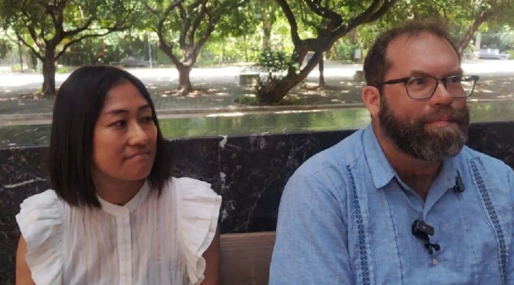
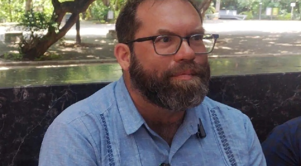
Archaeologist Brent Woodfill during the press conference on the discovery / Isaí López / El Heraldo de Chiapas
American archaeologist Brent Woodfill confirmed the discovery of the Lost City of the White Jaguar, an archaeological site located within the Montes Azules Biosphere Reserve, in the Lacandon Zone Community, near the border with Guatemala. This discovery was made with the support of the National Institute of Anthropology and History (INAH).
“Currently, there is not much to see, as the site is covered by vegetation; it is not recommended that tourists visit the site directly, although it is possible to visit other open areas within the Montes Azules Biosphere Reserve,” explained the archaeologist.
Woodfill explained that Jaguar Blanco is a new archaeological site discovered two years ago. Since then, its existence has become known, and recently, its authenticity has begun to be verified. “The name was given to it by the Lacandon people who inhabited that area,” he added.
The archaeologist spoke about the remains of Mayan communities that resisted Spanish colonization / Isaí López / El Heraldo de Chiapas
One of the sites closest to Jaguar Blanco is Chikultik, however, it is not yet open to visitors. Access is limited to authorized areas of the reserve, without the need to risk traveling to the archaeological site, located near the border with Guatemala.
During a press conference, the researcher highlighted the international importance of the discovery. He explained that Jaguar Blanco is one of the settlements in America that survived almost two centuries of conquest and colonization, resisting like many others in the Mayan world. “It was conquered in the 16th century, but it maintained its independence almost until the 18th century, even after the founding of Harvard University,” he said.
In that sense, he considered it one of the few peoples that resisted for so many years. “It is one of the few historical examples of prolonged resistance in the Americas.”
He also pointed out that the ancient inhabitants of Jaguar Blanco controlled a salt source in Guatemala, where he worked for twelve years. He commented that during the armed conflict in Guatemala, resistance communities also emerged that managed to survive in the jungle and mountains, escaping the Guatemalan army. “There are many parallels between that recent history and what happened during the colonial era, when the Lacandon people fled their capital and resisted for almost two centuries.”
He recalled that when the Spanish arrived, the Lacandones were settled in a village called Lacantún. They spoke a version of the language descended from the classical glyphs used at sites such as Palenque, Toniná, and Tikal. After colonization, many of them were taken to different areas of Chiapas and eventually ended up on the southern coast of Guatemala in the mid-18th century. “There they disappeared, although some returned to their homeland,” he concluded.